A Concise History and Significance of Fresno Street Names:
California, Ventura and Kings Canyon 1872 - 2023
The following is a brief history on the historic significance of Fresno’s street names: California, Ventura and Kings Canyon. This is not intended to be comprehensive but rather a glance at Fresno’s history of people, places and significance of street names. Additional references and supporting material can be found in the attached addendum at the end of this concise history.
History of South West, Central and South East Fresno
The 10.3-mile stretch of California, Ventura and Kings Canyon from Marks to Temperance is a roadmap into Fresno’s past, present and future. Driving east past Kearney’s Fruitvale Estate on California through downtown along Ventura past Holy Trinity Armenian Church and ultimately to the Scenic Highway and Kings Canyon National Park is a tapestry that is Fresno. Each distinctive thread connects to another and is central to Fresno’s history, founders, explorers and immigrants including Kearney, Roeding, Butler, Church, Berry, Easterby, Kitt, Laval, Lewis and Saroyan.
California Street
California Street formed the first east-west street alignment south of the downtown grid in 1881. Spanish explorers branded “California” as the State’s name in 1562. They named it California, after the mythical island in de Montalvo's 1510 book, because the explorers believed the Baja peninsula was an island, east of the Indies, similar to the island described in de Montalvo's novel and the name has remained.
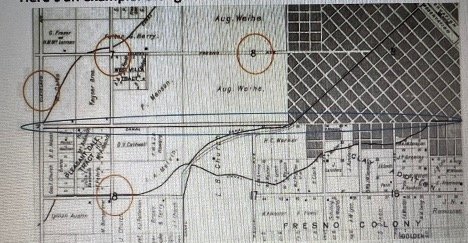
California Avenue appears to be one of the original names given to streets within the county. Be-cause it lies just on the edge of ‘town limits’ it is hard to find a precise date of when it came into existence, due to it being just outside the scope of downtown. The earliest map we could ascer-tain was for the Fresno Colony, recorded in August of 1881 for Thomas Hughes. It is the north-ern most street in the colony and although abbreviated Cala it is in line with where California Avenue is.
Ventura Avenue
Ventura Avenue is one of the original and earliest streets mapped by the Railroad establishing Fresno in 1872 to recognize California’s early history and Mission Buenaventura named by Father Junipero Serra in 1782.
Ventura Avenue (Gudde, 1998, p. 410), running parallel to the railroad tracks, is visible on the earliest Fresno map dating from 1873 to the present (150 years) recognizing California’s early history and Mission San Buenaventura named by Father Junipero Serra in 1782. Early settlers included Scandinavians, Volga Germans, Japanese, Chinese, Armenians, and later African Americans and Mexicans. The Chinese came to mine gold, build the railroads, dig irrigation canals, and later to take agricultural jobs and establish China Town (1872). In 1874, community members held a meeting establishing “redlining” and determined that Whites would settle east of the railroad tracks and other ethnicities and would be relegated to the west side. The 1882 Chinese Immigration and Exclusion Acts stemmed from economic and cultural tensions and ethnic discrimination, and ended an early source of farm labor. Japanese workers filled the gap working in the Valley’s fields eventually dominating the labor force in 1910. Forced Japanese internment in WW II led to the Bracero Program, which permitted millions of Mexican men to work legally in the United States on short-term labor contracts.
The first Armenians arrived in 1881 and eventually settled in a ten to twelve block area between the Santa Fe and Southern Pacific tracks appropriately called “Armenian Town.” The first Armenian Presbyterian Church was constructed in 1897 and Armenian architect Lawrence Karekin Conrajian built The Holy Trinity Armenian Apostolic Church at Ventura Street and M in 1914. It is the first church built in the tradition of Armenian Church architecture in the United States. I
Kings Canyon Avenue
Kings Canyon is a unique Fresno County treasure (Spitz, James, 2021. Treasures) and derives its name from the Kings River and Rio De los Santos Reyes (river of the Holy Kings, or the Three Wise Men from the Gospels) named by the Spanish Gabriel Moraga expedition in 1805. Subsequent explorations by the Whitney survey in 1864 of the upper reaches of the river discovered and named the “Kings River Canyon” ("a rival to Yosemite”).
Kings Canyon Road was created as Legislative Route 41, from General Grant Grove to the Kings River Canyon in 1905 and upgraded to Fresno in 1919. The "Irrigationists" (environ-mentalists), US Forest Service and Los Angeles wanted the "Canyon" flooded (aka Hetchy Hetchy and San Francisco) to build a 300-foot dam at Cedar Grove for the Kings River water-shed. Instead, the Fresno and California Chambers of Commerce were successful in asking that the Highway be completed to the Valley floor due to its essential economic value. The Kings River Canyon Highway was completed and dedicated October 29, 1939: "The completion of this project, which has been of considerable importance to the San Joaquin Valley Council of the State Chamber, makes available one of the most scenic tours of California about a three hour drive from the Valley via General Grant National Park." Source: Bancroft archives On November 14, 1950, the Fresno County Board of Supervisors re-designated the county portion of Ventura Avenue, and Highway 180 to Kings Canyon National Park as Kings Canyon Road for its National and local importance to Fresno. (Fresno Bee, November 15,1950)